The recent release of the following detailed geology data contains a geodatabase of feature classes of structure, surface and solid rock unit layers, as well as shapefiles and MapInfo tab files. As in the previous releases, symbology is represented in ESRI layer files and refer to the feature classes inside the geodatabase. In this release the .lyr and .lyrx files also include labelling. Further details on updates in this release are listed below.
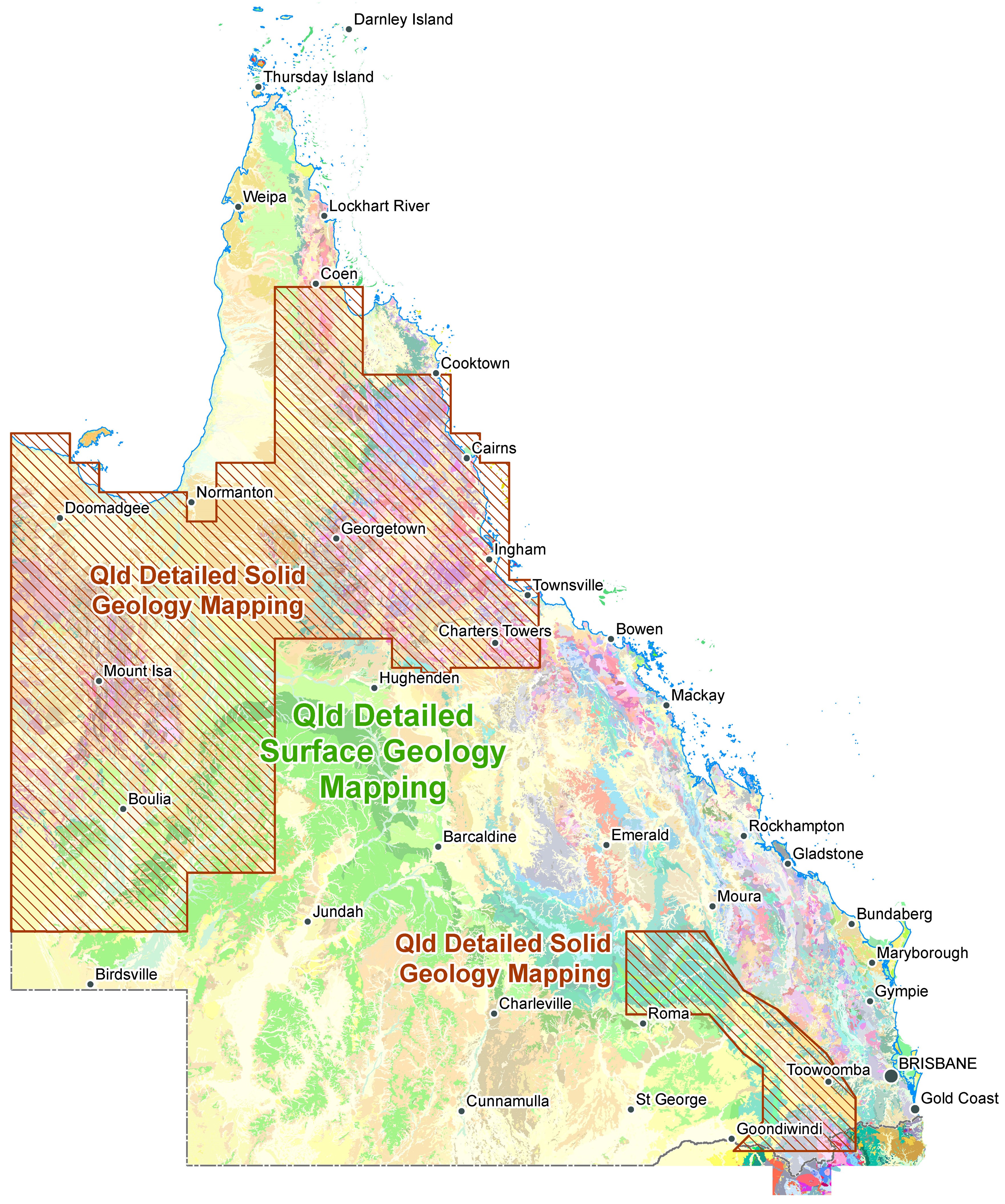
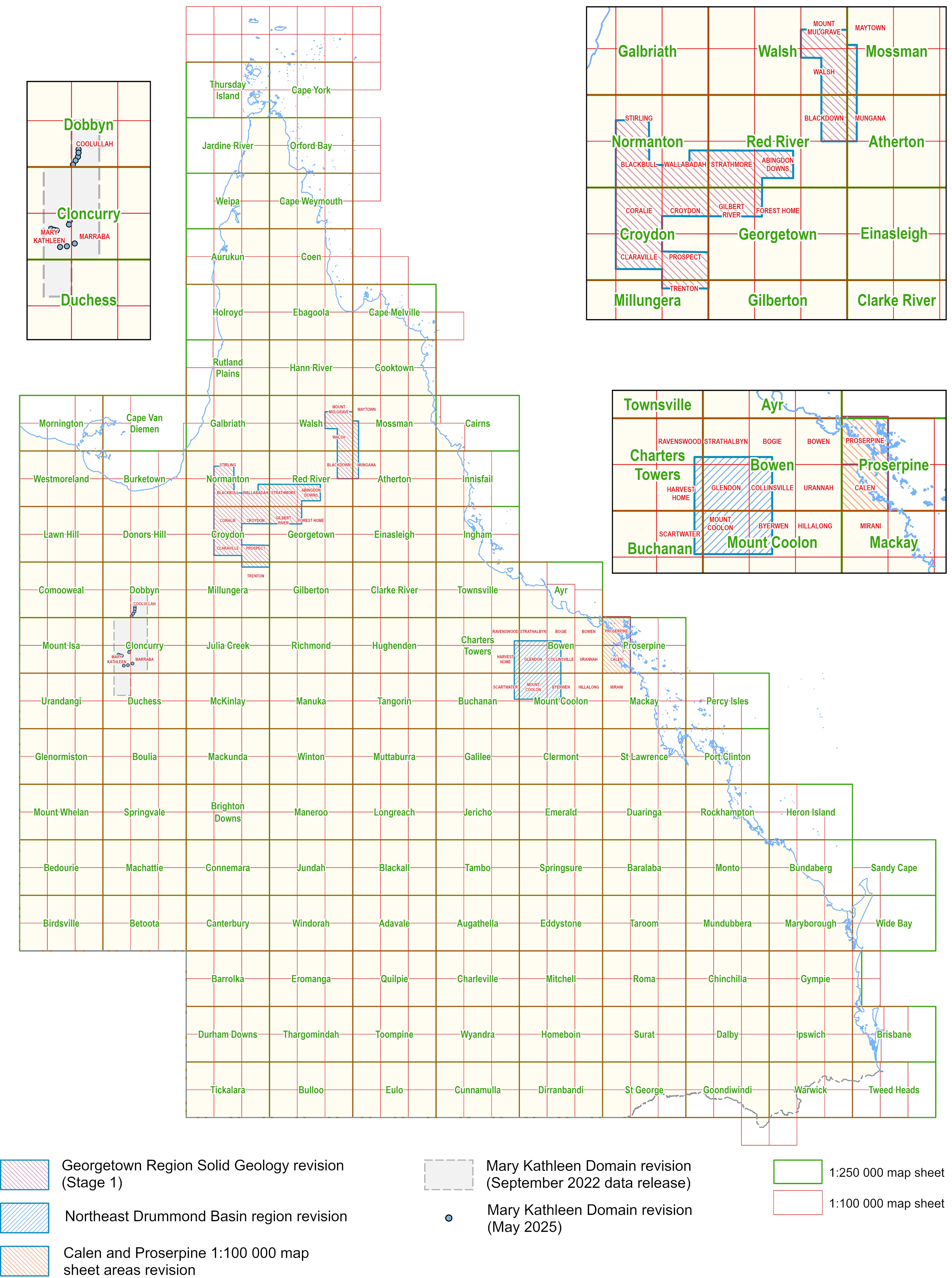
Detailed Surface and Solid Geology Data extents—May 2025
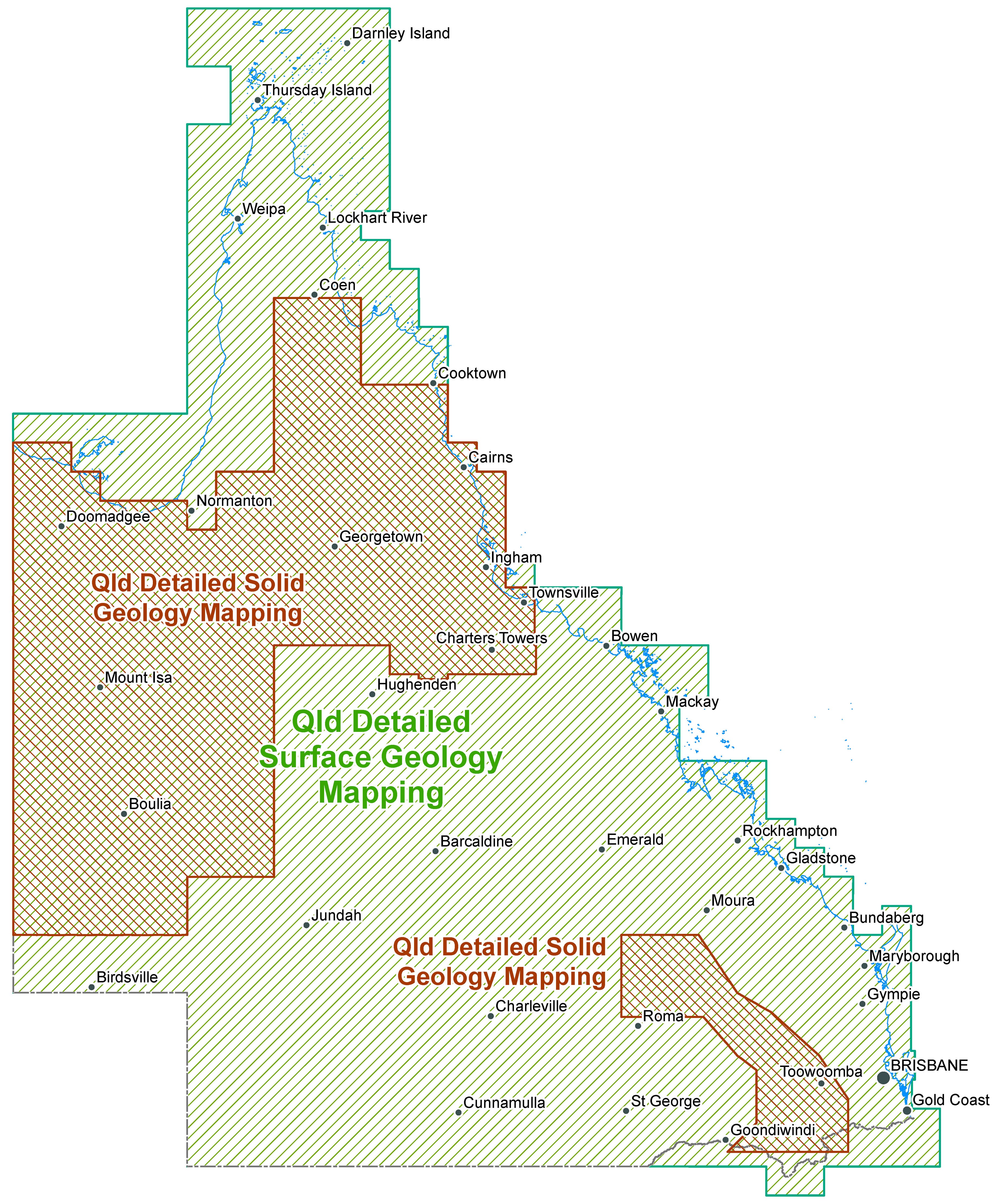
For more information please refer to the detailed geology data index and geological compilation map index.
Since the September 2023 data release, new or revised compilation maps of various types and scales have been generated over the August 2022 and September 2023 data release areas. For further details refer to the geological compilation map index above. New maps will be generated over the current data release area (May 2025) and made available on or before September 2025.
State-wide Detailed Geology Data Capture Project
All areas covered by new or revised data will have new compilation maps generated. These maps are available from the GSQ Open Data Portal.
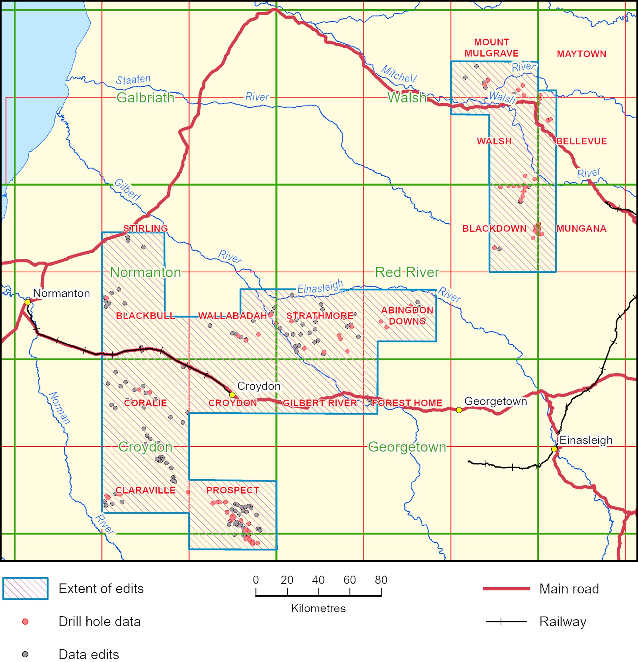
Georgetown Region Solid Geology revision—Stage 1
This revision of the solid geology of the Georgetown–Croydon region is based mainly on a study of drill core held by the Geological Survey. Basement cores from more than forty holes were examined and a diverse array of rock types identified, highlighting the difficulty in integrating the solid geology interpretation, based mainly on remote sensing (aeromagnetic) data, with the surface geology coverage based mainly on field observations.
Samples have been submitted for isotopic dating to gain a better idea of the characteristics of basement rock units and how they relate to surface geology units. Results obtained enhance and modify the established geological framework for the Georgetown–Croydon region (Kositcin & Bultitude, 2024; Kositcin & Bultitude, in preparation).
Holes drilled north, and northwest of Croydon intersected essentially unmetamorphosed sedimentary rocks (mudstone, siltstone, fine-grained sandstone) assigned to solid geology unit L characterised by low, relatively uniform magnetisation. Farther east, muscovite schist intersected in a hole drilled northwest of Georgetown was also originally included in solid geology unit L, based solely on its magnetic response. This very extensive basement unit formed part of the Kowanyama Province as depicted by Bain & Draper (1997) but is part of the younger Savannah Province based on recently obtained maximum depositional ages that range from ~1635 Ma (muscovite schist northwest of Georgetown) to 1570 Ma (quartzose sandstone northwest of Croydon).
Another significant result from this study is the recognition of an igneous complex (Coralie Igneous Complex) ~50 km west of Croydon yielding early Carboniferous isotopic ages, making it one of the oldest known units in the Kennedy Igneous Association.
This revision of the solid geology was made using aeromagnetic data based on ~4 km flight line spacings. Reinterpretation of the solid geology of the Red River 1:250 000 Sheet area is about to commence using high-quality aeromagnetic data based on ~1 km flight-line spacings over part of the area.
BAIN, J.H.C. & DRAPER, J.J. (compilers), 1997. Atlas of North Queensland Geology, 1:3 million scale. Australian Geological Survey Organisation/Geological Survey of Queensland, 93 pp. https://geoscience.data.qld.gov.au/data/report/cr088850
KOSITCIN, N. & BULTITUDE, R.J., 2024. New SHRIMP U–Pb ages from the Georgetown and Cairns Regions Queensland: NE Queensland Solid Geology Project, 2023–2024. GSQ Record 2024/01, Geological Survey of Queensland. GA Record 2024/51, Geoscience Australia, Canberra. https://dx.doi.org/10.26186/149794 and https://dx.doi.org/10.26186/149794
Revision 2023–2024 by R.J. Bultitude, Minerals Geoscience, Geological Survey of Queensland, Department of Natural Resources and Mines, Manufacturing, and Regional and Rural Development.
GUIDE TO STAGE 1 EDITS
INDEX TO 1:100 000 MAPS
1:250 000 maps shown in green
Northeast Drummond Basin region revision
This release contains significant updates to the detailed surface geology of the Mount Coolon (8355) and Glendon (8356) 1:100 000 map sheet areas. This region is considered prospective for epithermal mineralisation and hosts widespread alteration systems. Previous geological mapping over parts of the area at 1:250 000 scale (Hutton and Rapkins, 1997) and 1:100 000 scale (Oversby et al., 1995) had resulted in discrepancies across the Glendon and Mount Coolon sheet boundaries including differences in the definition of basement units, the division and mapping of Drummond Basin units and the division of the Bulgonunna Volcanics. Additionally, some very large areas of undivided granitoids remained and differentiation between volcanic rocks of the Bulgonunna Volcanic Group versus the Drummond Basin was unclear. To resolve these issues and to build from a major regional mapping project over the remainder of the Drummond Basin (Blake et al., 2012), the Geological Survey of Queensland completed a work program in the northeast Drummond Basin region involving significant field mapping, geochronology and geochemistry (see Purdy et al., 2016). Field mapping was completed over multiple seasons between 2004 and 2008 and was complimented by interpretation of magnetic and radiometric data, air photos and satellite imagery. The resulting surface geology mapping updates are presented in this release.
BLAKE, P.R., WITHNALL, I.W., FITZELL, M.J., KYRIAZIS, Z. & PURDY, D.J., 2012: Geology of the western part of the Drummond Basin. Queensland Geological Record, 2012/17. https://geoscience.data.qld.gov.au/data/report/cr089862
HUTTON, L.J. & RAPKINS, R.J., 1997: Mount Coolon Sheet SF 55-7, Queensland, 1:250 000 geological map series, second edition. Department of Mines and Energy, Queensland. https://geoscience.data.qld.gov.au/data/map-collection/mr000318
OVERSBY, B.S., MACKENZIE, D.E., McPHIE, J., LAW, S.R. & WYBORN, D., 1995: Geology of the Burdekin Falls Dam - “Conway” Area, 1:100 000 scale map. Australian Geological Survey Organisation. https://geoscience.data.qld.gov.au/data/map-collection/mr000262
PURDY, D.J., WITHNALL, I.W. & BULTITUDE, R.J., 2016: Geology, geochronology and geochemistry of the northeast Drummond Basin region. Queensland Geological Record 2016/01. https://geoscience.data.qld.gov.au/data/report/cr096281
Calen and Proserpine 1:100 000 map sheet areas revision
Revision of the surface geology of the Calen and Proserpine 1:100 000 Sheet areas is based on limited fieldwork conducted between 2007 and 2010 and in 2022 by Geological Survey of Queensland (GSQ) personnel, interpretation of airborne geophysical data, drilling data, and the results of investigations carried out by university and other investigators. The Airlie Block was studied by John Parianos (1993) as a M.Sc. project, and the current update of the Proserpine 1:100 000 Sheet area is based on the detailed map of the block included in his thesis and the results of limited isotopic dating (Cross et al., 2013; Seigal, 2015).
The main aims of the project were to update the 1960s reconnaissance-style mapping of the Proserpine 1:250 000 Sheet area by Bureau of Mineral Resources–GSQ personnel, and to create seamless joins with adjacent sheet areas, which were updated by the Geological Survey in the mid-1990s to early 2000s.
Revision 2022-2023, Calen 1:100 000 Sheet area, by J.S Spence; 2024–2025, Proserpine 1:100 000 Sheet area, by R.J. Bultitude; Minerals Geoscience, Geological Survey of Queensland, Department of Natural Resources and Mines, Manufacturing, and Regional and Rural Development.
CROSS, A.J., BULTITUDE, R.J., PURDY, D.J., 2013. Summary of Results — Joint GSQ–GA Geochronology Project: Ayr, Bowen, Eulo, Mount Coolon, Proserpine and Warwick 1:250 000 sheet areas. Queensland Geological Record, 2012/19. https://geoscience.data.qld.gov.au/data/report/cr089851
PARIANOS, J.M., 1993. Carboniferous to Tertiary Geology of the Airlie Block, northeast Queensland. M.Sc. Thesis, Department of Earth Sciences, The University of Queensland.
SEIGAL, C., 2015. Heat-Producing Element Enrichment in Granitic Rocks, the Role of Crustal Composition and Evolution. Ph.D. Thesis, School of Earth, Environmental and Biological Sciences, Queensland University of Technology.
SPENCE, J., 2023. Updates to the Geology of the Calen and Proserpine 1:100 000 Map Sheets. Queensland Geological Record 2023/05. https://geoscience.data.qld.gov.au/data/report/cr143974
Mary Kathleen Domain Revisions
Current data release May 2025
- Coolullah (part) recognition of a new unit, Sparklet Rhyolite, formerly mapped as Argylla Formation north of Kajabbi.
- Mary Kathleen (part) minor retagging of polygons and refinement of boundaries delineating subunits within the Argylla Formation, Ballara Quartzite and Corella Formation.
These changes were identified during current work documenting the 2005-2010 GSQ revision of the Eastern Succession of the Mount Isa Province.
Revision 2025 by I.W. Withnall volunteer Geoscientist, Minerals Geoscience, Geological Survey of Queensland, Department of Natural Resources and Mines, Manufacturing and Regional and Rural Development.
Data release August 2022
Coolullah (part), Prospector (part), Quamby (part), Mary Kathleen (part) Marraba (part) and Duchess (part) 1:100 000 map sheet areas
Revision 2018–2022 by R.J. Bultitude and D.J. Purdy, Minerals Geoscience, Geological Survey of Queensland, Department of Natural Resources and Mines, Manufacturing, and Regional and Rural Development. See Bultitude et al., 2021 for summary. https://geoscience.data.qld.gov.au/report/cr126281
Line ID descriptions for data extents—May 2025
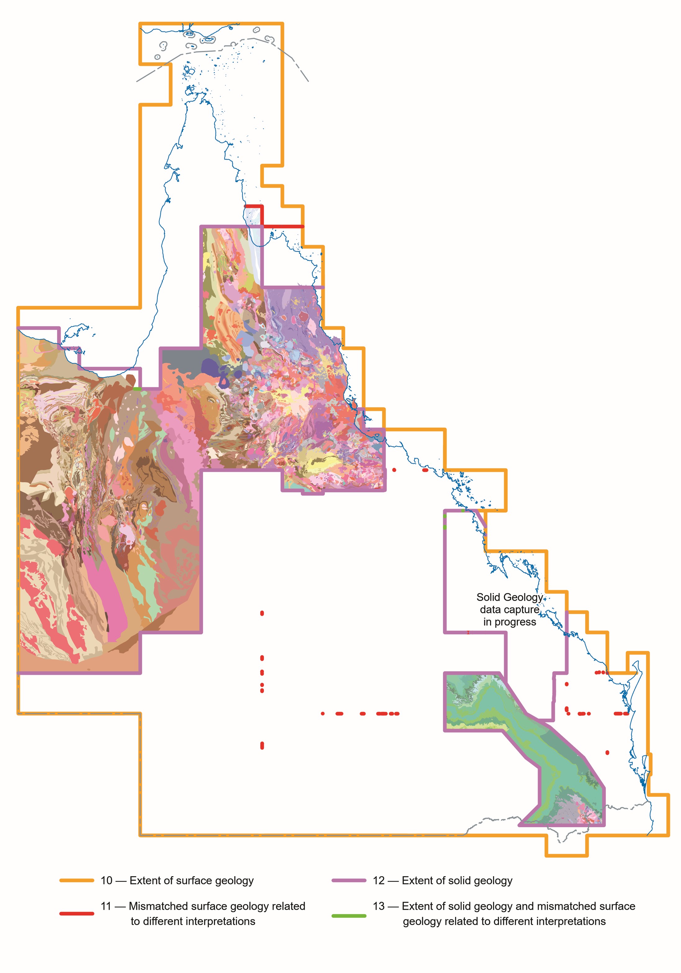
Revision of Line ID description derived from Geophysical imagery
Prior to about 1990 geological linework was mostly derived from airphoto interpretation and field observations. Since then, geophysical imagery has become an ever increasingly important tool used by geoscientists to interpret the basement rocks where they are covered by extensive areas of surficial deposits such as Mesozoic and Cenozoic rocks of the Carpentaria and Karumba basins.
The departmental detailed geology structure dataset currently incorporates the linework for both the basement and surface geological interpretations of Queensland’s geology. All geophysical linework was originally shown using solid magenta lines of different widths, reflecting standard geological line symbology. All these subsurface boundaries were regarded as being concealed/approximate.
With increased computer processing power and storage capabilities it was decided to be more specific and indicate via ‘Capture Method’, the geophysical imagery type and to show all future linework using standard mostly black geological symbology.
Over time, this has resulted in lines interpreted using geophysics, being shown in magenta in some areas, and in other areas of more recent mapping, shown in black. An attempt to standardise usage has been made in this data release, with all linework derived from interpretation of geophysical data now, magenta. The type of geophysical data used is still described in the ‘Capture Method’ data field.
We aimed for greater consistency with these changes however not all conflicts have been resolved, and some exceptions made. The contrast between magenta and black linework will hopefully make the Surface Geology easier to distinguish from the Basement Geology. More updates will be included in future releases of the digital geological data. Any feedback on these data presentation changes is highly valued and would be greatly appreciated.
Please e-mail your comments to:
Geological Information
Department of Natural Resources and Mines, Manufacturing and Regional and Rural Development
geological_info@nrmmrrd.qld.gov.au
Attn: Geoscience Data Management Team, Spatial Information
Revised and new geology updates—May 2025
Proposed updates, September 2025 data release
- Stage 1, Cloncurry region Central Eastern Fold Belt revision
- Stage 2, Cloncurry region Central Eastern Fold Belt revision
Proposed data releases 2026
- Stage 3, Cloncurry region Central Eastern Fold Belt revision
- Mackay Region Solid Geology interpretation
Approximate detailed data capture scales, May 2025
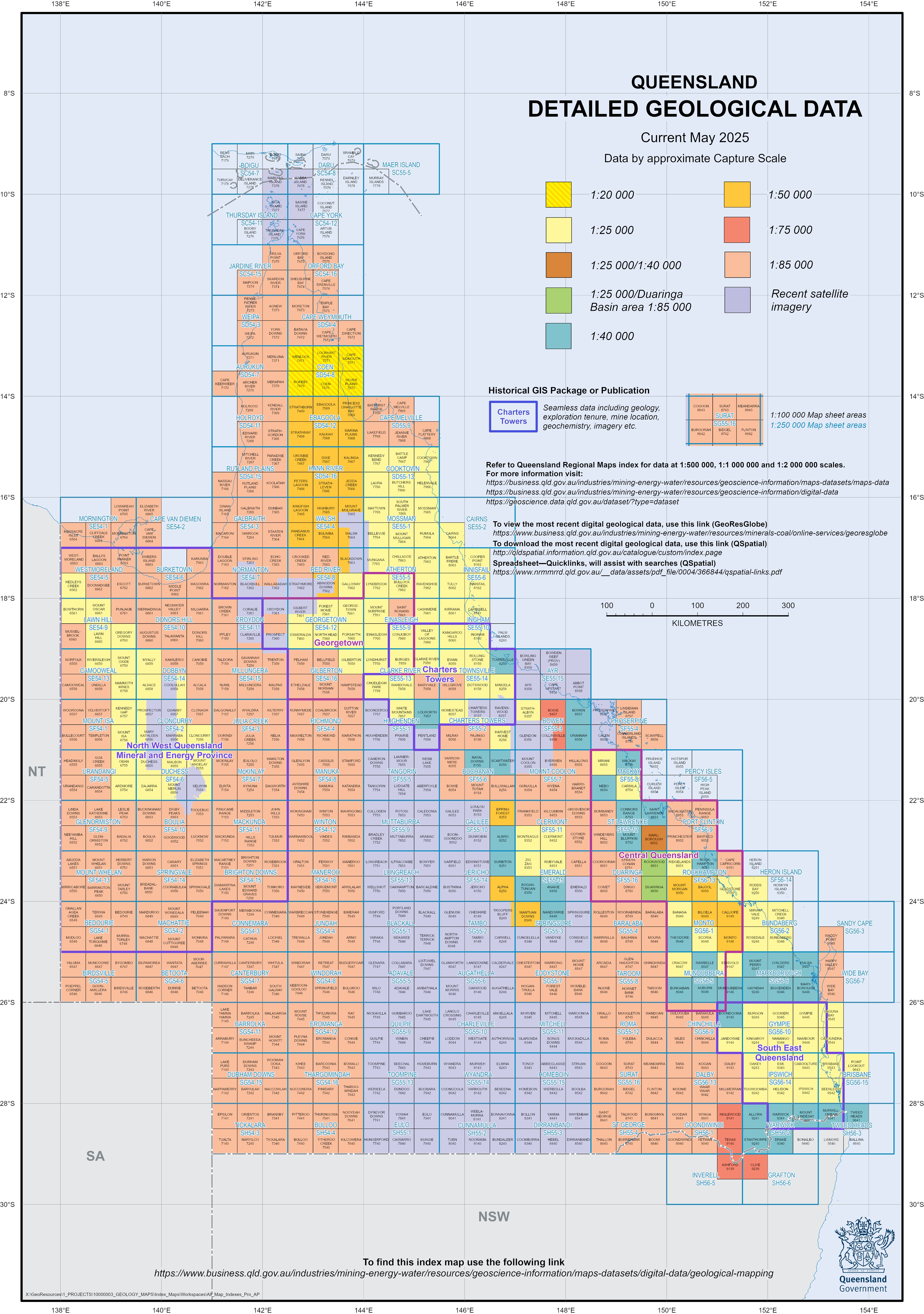 Detailed Geology Data Release—May 2025