The geophysics layer group in GeoResGlobe has been updated to:
- Draw survey attributes from the corporate Geological Properties database.
- Link to reports and datasets in the GSQ Open Data Portal.
- Use more logical naming and hierarchy of layers.
- Use improved symbology.
- Present data in GDA2020.
Layer order changes
- Surveys regrouped into Airborne, Ground, Seismic and Hyperspectral .
- Seismic surveys now categorised by 2D and 3D lines and areas.
- Airborne surveys now grouped by observation type (magnetic, radiometric, electromagnetic, and gravity-gradiometry).
- Gravity base station and gravity data station point layers removed (due to slow redraw and limited use).
Symbol and appearance changes
- Magnetotelluric surveys simplified to single symbol.
- New symbology for amended layers as listed above (refer to Legend).
Data
- Updated schemas to align with the Geological Properties database (refer to Field Structures).
- Seismic data converted to GDA2020.
- 7 new 3D Seismic Surveys (areas).
- 171 new 2D Seismic Lines (lines).
Legend
| Old | New |
|---|---|
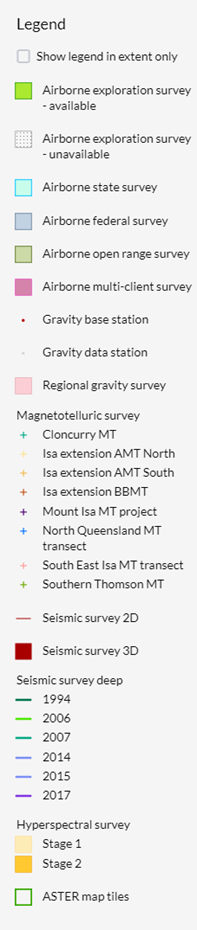 |
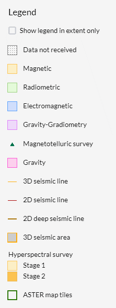 |
Field Structures
Seismic Lines (2D, 3D and Deep)
| Field Name | Change Type | Change Description | Field Description |
|---|---|---|---|
| Survey Line | New field | Primary key. Unique identifier of each survey line across the entire dataset. Combination of Survey No and Line name | |
| Line Name | Renamed field | Previously 'Line ID' | Unique identifier of each line, within the seismic survey |
| Survey No | Retained field | Unique identifier for each seismic survey | |
| Survey Name | Retained field | Name of survey | |
| Survey PID | New field | Persistent Identifier of seismic survey data package in GSQ Open Data Portal | |
| Survey Method | New field | Method of collection, eg ground survey, marine survey | |
| Observation Type | New field | Observation type, eg 2D or 3D | |
| Depth | New field | Depth of survey. Eg standard or deep survey | |
| Operator | Renamed field | Previously 'Operator Name' | Who commissioned the survey |
| Contractor | New field | Contractor that undertook the survey (where applicable) | |
| Permit | New field | Relevant Resource Authority eg ATP123, EPC123 | |
| Status | New field | Status of survey eg Interim report received, Final report received, Survey completed | |
| Commence Date | New field | New field to GRG, not previously shown | Commencement date |
| Completion Date | Renamed field | Previously 'End Date' | Completion date |
| Length (km) | New field | Length of survey line in kilometres | |
| Report PID | Renamed field | Previously 'Main company report no' | Persistent Identifier of survey report in GSQ Open Data Portal (where available) |
| OpenData Link | New field | Link to report in GSQ Open Data Portal (where available) | |
| Access Right | New field | Access rights assigned to report, eg Open Access | |
| Line ID | Retired field | ||
| Operator code | Retired field |
Seismic Areas
| Field Name | Change Type | Change Description | Field Description |
|---|---|---|---|
| Survey No | Retained field | ||
| Survey Name | Retained field | ||
| Survey PID | New field | Persistent Identifier of seismic survey data package in GSQ Open Data Portal | |
| Survey Method | New field | Method of collection, eg ground survey, marine survey | |
| Observation Type | New field | Observation type, eg 3D | |
| Depth | New field | Depth of survey. Eg standard or deep survey | |
| Operator | Renamed field | Previously 'Operator Name' | Who commissioned the survey |
| Contractor | New field | Contractor that undertook the survey (where applicable) | |
| Permit | New field | Relevant Resource Authority eg ATP123, EPC123 | |
| Status | New field | Status of survey eg Interim report received, Final report received, Survey completed | |
| Commence Date | New field | New field to GRG, not previously shown | Commencement date |
| Completion Date | Renamed field | Previously 'End Date' | Completion date |
| Area (sq. km) | New field | Area of survey line in kilometres | |
| Report PID | Renamed field | Previously 'Main company report no' | Persistent Identifier of survey report in GSQ Open Data Portal (where available) |
| OpenData Link | New field | Link to report in GSQ Open Data Portal (where available) | |
| Access Right | New field | Access rights assigned to report, eg Open Access | |
| Survey length (km) | Retired field | ||
| Contact | Retired field |
Airborne Survey
| Field Name | Change Type | Change Description | Field Description |
|---|---|---|---|
| PID | Retained field | Unique identifier | |
| Parent PID | New field | Parent Identifier in GSQ Open Data Portal | |
| Survey Name | Retained field | Survey name | |
| Survey No | Retained field | Survey number | |
| Survey Method | New field | Survey method eg Airborne | |
| Observation Types | New field | Amalgamation of previous Magnetic, Radiometric, Electro-magnetic and Gravity data fields | |
| Commence Date | New field | Replaces Date Flown | Commencement date of survey |
| Completion Date | New field | Replaces Date Flown | Completion date of survey |
| Operator | Renamed field | Previously Client | Who commissioned the survey |
| Contractor | Retained field | Contractor that undertook the survey (where applicable) | |
| Survey Status | New field | Status of survey eg Interim report received, Final report received, Survey completed | |
| Access Right | Renamed field | Previously Open File Flag | Access rights assigned to report, eg Open Access |
| Interval (m) | Retained field | Interval (m) | |
| Survey Length (km) | Renamed field | Previously Total Line (km) | Survey Length (km) |
| Flight Height (m) | Retained field | Flight height | |
| OpenData Link | New field | Link to GSQ Open Data Portal resources | |
| Observation Type | New field | Observation type eg Electromagnetic, Gravity-gradiometry, Magnetic | |
| Extent type | Retired field | ||
| Portion | Retired field | ||
| Data available | Retired field | ||
| Date flown | Retired field | ||
| Air survey type | Retired field | ||
| Line direction (deg) | Retired field | ||
| Tie-line direction (deg) | Retired field | ||
| Magnetic data | Retired field | ||
| Radiometric data | Retired field | ||
| Electro-magnetic data | Retired field | ||
| Gravity data | Retired field | ||
| Contact | Retired field | ||
| Comments | Retired field |
Hyperspectral Survey
| Field Name | Change Type | Change Description | Field Description |
|---|---|---|---|
| Survey No | New field | Survey number | |
| Survey PID | Retained field | Unique ID | |
| Survey name | Retained field | Survey name | |
| Survey description | New field | Survey description | |
| Access right | New field | Access rights assigned to report, eg Open Access | |
| OpenData Link | New field | Link to GSQ Open Data Portal resources | |
| Stage | Retired field | ||
| Survey area | Retired field |
ASTER map tiles
| Field Name | Change Type | Change Description | Field Description |
|---|---|---|---|
| PID | New field | Unique ID | |
| Tile name | Retained field | ||
| Description | Retained field | ||
| OpenData Link | New field | Link to GSQ Open Data Portal resources | |
| ID | Retired field |
Ground Survey – Gravity and Magnetotelluric
| Field Name | Change Type | Change Description | Field Description |
|---|---|---|---|
| PID | Retained field | Unique identifier | |
| Parent PID | New field | Parent Identifier in GSQ Open Data Portal | |
| Survey Name | Retained field | Survey name | |
| Survey No | New field | Survey number | |
| Survey Method | New field | Survey method, e.g. Ground | |
| Observation Types | New field | Observation types relevant to survey, eg Gravity, Magnetotelluric | |
| Commence Date | New field | Commencement date of survey | |
| Completion Date | New field | Completion date of survey | |
| Operator | Renamed field | Previously 'Company' | Who commissioned the survey |
| Contractor | New field | Contractor that undertook the survey (where applicable) | |
| Survey Status | New field | Status of survey eg Interim report received, Final report received, Survey completed | |
| Access Right | New field | Access rights assigned to report, eg Open Access | |
| Interval (m) | Renamed field | Previously 'Spacing' | Interval (m). Gravity layer only |
| Survey Length (km) | New field | Survey Length (km) | |
| OpenData Link | New field | Link to GSQ Open Data Portal resources | |
| Observation Type | New field | Observation type of this record, eg Gravity, Magnetotelluric | |
| Spacing | Retired field | ||
| Date | Retired field | ||
| Contact | Retired field |